Eyal Weizman and Books of Destruction

Eyal Weizman in the LRB on Israel’s strategies of spatial control over Gaza — and Israel’s cynical, shocking legal acrobatics to consider a Palestinian civilian in Gaza as a “voluntary ‘human shield.'”

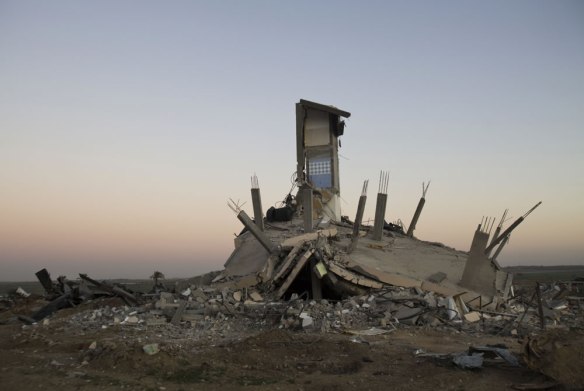
We will learn more about the way Pillar of Defence was conducted when, over the coming weeks, it becomes possible to start reading the rubble. Some of what we know about the 2008-9 assault comes from an archive – the Book of Destruction – compiled by the Hamas-run Ministry of Public Works and Housing. The archive contains thousands of entries, each documenting a single building that was completely or partly destroyed, recording everything from cracked walls in houses that still stand, to complete ruins. The ministry will no doubt put together a new archive following the latest attack. Its list will be a close parallel to the one contained in a document owned by the Israeli military. This is the Book of Targets in Gaza, a thick blue folder that the outgoing chief of staff, Gabi Ashkenazi, who presided over Operation Cast Lead, passed to his successor in a televised ceremony at the beginning of 2011: ‘I want to hand over something I carry with me all the time,’ he announced.

Now that the bombing is over, evidence will be accumulated (and allegations made and contested), not only by speaking to survivors and witnesses but by using geospatial data, satellite imagery of destroyed buildings and data gathered in on-site investigations. But investigation is difficult: in Gaza ruins are piled on ruins, and it isn’t easy to tell them apart. The wars of 1947-49, the military incursions of the 1950s, the 1956 war, the 1967 war, the 1972 counterinsurgency in the refugee camps, the first intifada of 1987-91, the waves of destruction during the second intifada of the 2000s, and now the two attacks of 2008-9 and 2012, have each piled new layers of rubble on top of those produced by their predecessors.

The Book of Destruction is also a haunting publication by the excellent photojournalist Kai Wiedenhöfer, published after the last war on Gaza in 2008-09. Get it. Both photos in this post are from Wiedenhöfer’s book.

Egyptorama, or desert highways

“A lonely door built in the middle of the desert, a forest of lampposts, a mosque shaped like a spaceship; emptiness turns brutally into strangeness, creating a tension between people and their environment. This is Egyptorama—a road trip that leads nowhere.”

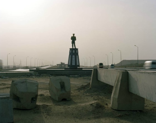
Stark photos by Julian Chatelin on Guernica that capture the Egyptian military’s role in the transformation of the country’s physical (and political) landscape. Abandoned tracts of desert are either unused military installations or, more often on the fringes of Cairo, state-military land sold to speculators close to the regime, to build an unsustainable and largely unrealized suburban dream in the desert. Via Arabist.

Zamalek 1896

The island of Zamalek in earlier days, before it was Cairo’s leafy enclave on the Nile. Both photos read, “The quarter (district, neighborhood) of Zamalek, 1896.”

I’m posting these photos partly in reply to Mohamed’s new blog, Vintage Egypt: a visual history of mid-twentieth century Egypt (more or less?) in old advertisements. For a later but still historical image of Zamalek, here is one he found:

The politics of restoration on Sharia al-Mu’izz

All of the buildings refurbished by the government’s Historic Cairo Restoration Project around Sharia al-Mu’izz have a marble plaque to commemorate their reopening after restoration. This is expressed, of course, in gaudy script that honors the patronage and support of the president, Hosni Mubarak, his wife Suzanne, the culture minister, Farouk Hosny, and Abdel Azeem Wazeer, governor of Cairo. This plaque, commemorating the reopening in February 2010 of the complex of Sultan Barquq on Sharia al-Mui’zz, has been defaced since the January 25 revolution.The government’s Historic Cairo project was solely economic development through heritage tourism, which is their only strategy and motivation for architectural restoration and preservation. The area aimed to turn the historic spine of medieval Cairo into a controlled pedestrian zone; cars would only be allowed in the evenings, with traffic heavily controlled or restricted during the day. The new promenade, lined with antique and shisha shops, glows in the evening thanks to professional lighting from Italy. A travel writer for the New York Times basked in “A Cairo Street Free from Traffic and Haggling.” Not surprisingly, the refurbishment of al-Mu’izz was and continues to be criticized as a beautification of the facades on al-Muizz only, or a Disney-fication of the historic heart of Fatimid Cairo. The alleys extending off the main street in either direction in Gamaliyya are home to scrap metal shops that the previous regime wanted to expel. Residents applaud the infrastructure improvements, like the new sewage system and street paving. But the HCRP’s creation of a plaza outside al-Hakim required removing the busy lemon, onion and garlic markets — banished to al-Obour off the highway to Ismailiya on the fringes of Cairo, according to people I talked to there. Tourists want open space with row upon row of shisha shops, according to the government’s plan; they don’t want the shaabi activities of vegetable markets for the people who actually live there.

The HCRP was not urban renewal but heritage tourism in the busy, medieval center of Cairo. The Ministry of Culture’s dream of turning al-Muizz and the rest of Fatimid Cairo into an “open-air museum,” however, is on hold, and hopefully has been dashed. Since January, al-Muizz is full of cars and motorcycles and micro-trucks again — since the revolution, there has been no enforcement of al-Mui’zz as a pedestrian zone. Police are few. The realities of the city, and its place as a bustling commercial area, have overtaken the government’s plan in the absence of enforcement.

Bonfils photo of Barquq from Archnet.

How does the architecture and its management and restoration impact the relationships with residents in the area and the state? The Ministry of Culture, and the Supreme Council of Antiquities, approach historic buildings as lifeless and without context, designating them as monuments with little connection or vitality for the people living next door. They have to be treated exclusively as visitors’ sites, a place for a tourist to see. The complexes of Qalawun and Barquq, of course, are sites of major religious, historical and architectural importance in Cairo — and yet their restoration has removed them from street-level activities and made them only a backdrop for tourists, with professional lighting at night. Qalawun is no longer a congregational mosque. Both it and Barquq are only open until the early afternoon, though people on al-Muizz say this is for security reasons in the absence of police and the threat of looters.

For many Egyptians, restoration and the Historic Cairo project on al-Mui’zz evoke the fraud and vanities of former culture minister Farouk Hosny. His former deputy Ayman Abdel Moneim directed the project until he went to jail for corruption in 2007. As Moneim told Ahram Weekly earlier that year:

“This two-year long survey will result in integrated socio-economic revitalisation plan linking the urban and the socio-cultural fabric of the city’s core,” Abdel-Moneim confidently predicted, adding that its provisions would be enshrined in legislation to preserve monuments and protect the area from further encroachment.

Moneim was sent to prison, convicted of taking money from the contractors doing the restoration work, in addition to other charges of bribery. There is nothing to suggest in the HCRP a social development or integrated revitalization project. One architect I spoke to cynically said that the impetus and goal of the project was to add a day to the tourists’ itinerary of Cairo — after the Pyramids, and the Museum, the government hoped, visitors could wander al-Muizz and the sanitized alleys of Fatimid Cairo beyond Khan al-Khalili.

If people are isolated from their own architectural heritage, which is seen to be used and protected only to serve regime corruption and neoliberal economic policies, what is left? What is the local, lived impact of restorations carried out for narrow economic interests under urban authoritarianism?

For one, it starts with defacing the marble plaque that commemorates the restoration project of the Barquq complex. The plaque does not acknowledge the building’s history or architecture, but instead the patronage of the regime that insisted on owning culture and urban heritage.


Possibilities in Tahrir

I’ve been looking at this picture — an old postcard of Tahrir I got in Cairo in 2009 and now have on my book shelf in England — since January 25th.

Today I read this essay by Mohamed ElShahed in the Architect’s Newspaper, about the history of architectural possibilities in Midan Tahrir, and I had to approach the picture again:

With the current revolution underway, architects, planners, and dreamers have been calling for meetings, discussions, and debates on what to do with the square. Topics of discussion include: should it be redesigned and how; how will the revolution and the martyrs be memorialized; and should it be renamed…

… Cairo has always been a city of great works of architecture and intelligent city planning. It is also a city marked by many failures at the hands of hasty architects and unimaginative politicians. Yet no one politician or architect has been able to lay claim over the design and symbolism of Tahrir Square, which remains as a collection of fragments from many failed or unfinished plans and urban fantasies.

An appropriate book arrived in the mail today, just in time for questions of urban modernity in the Middle East. I’ve been looking for pieces about Tahrir’s architectural history and how the built environment affected political action in the Egyptian revolution, and this other very interesting piece by ElShahed gets at that, with great photos of Tahrir in the early 1960s and in the Mubarak years, when everything green was replaced by permanent construction sites and hemmed by fences, “part of the government’s policy of discouraging public assembly.”

The statue-less column in the center of the midan is long gone, though we can still remember it with Sonallah Ibrahim:

The importance of this square does not lie in the fact that it constitutes the center of the city, or that it is surrounded by strategically important buildings like the Hilton Hotel, the Egyptian Museum, the Mugama (which comprises 1,400 offices occupied by thirty thousand employees who deal with sixty thousand people per day), and the American University. Nor is it important because at its center stands an empty statue base erected twenty-five years ago, after the death of Abd al-Nasser, for which the Egyptians have yet to choose a personality to occupy it; nor because, according to a popular joke initially targeting one of the Arab kings, it is the space used by the prime minister to distribute the national budget: he stands at the center of the square and hurls the national budget into the air, taking what lands on the ground for himself and giving what remains in the air to the people.

Nasser in Damascus

234-724  February 1958 and the declaration of the United Arab Republic. Looks like Merjeh thereabouts from the view to Mt. Qassioun. From this invaluable web archive of Nasser that includes a glut of photos, speeches, recordings, etc. Fully searchable collection run by the Biblioteca Alexandria. In many ways the site is the very opposite of going to the library in Egypt (with AUC’s brand-new, USAID-made library one exception) — a bureaucratic affair that is often, like the “Greater Cairo Library” in a palace in Zamalek, never open.

Beware the cost of war, and representation, and…

Picture 4

Hanna is in Gaza and has a blog. It’s not always about what she does in the world’s largest open air prison — there are other topics: architecture, photography, women, the museum. But here she writes about a current exhibition of Israeli and Palestinian photographers in London, “Beware the Cost of War,” that removes credits and captions from images of Israel and Palestine (for many of the photos, its Gaza and southern Israel last winter, specifically) as a way of looking, hopefully, at conflict devoid of identity, ideology, politics. It’s interesting, gruesome, and mostly it works. The New York Times photo blog covered the show and quotes organizer, Israeli photographer Yoav Galai: “People want to see the world as they see it: there’s good guys and bad guys.. I wanted to give the pictures back to the photographers. Away from the headlines. Away from pro- or anti-something. So you can see the reality of the conflict.”

Picture 6

The images represent the conflict, and they’d come to represent “one side” if printed in a newspaper and given a caption, we are supposed to believe. Like Hanna, I looked for the first sign of Israeli or Palestinian in every photograph — the Star of David on the medic’s vest, for one. (Actually it’s quite easy to pick out the Palestinians, by the quality of clothes and the extent of wounds and destruction). This proves the curator’s point, in a way, that we need to connect suffering with its subject, presumably to lay blame and understand its context. Galai said he was inspired by this bit of Susan Sontag’s Regarding the Pain of Others:

To an Israeli Jew, a photograph of a child torn apart in the attack on the Sbarro pizzeria in downtown Jerusalem is first of all a photograph of a Jewish child killed by a Palestinian suicide-bomber. To a Palestinian, a photograph of a child torn apart by a tank round in Gaza is first of all a photograph of a Palestinian child killed by Israeli ordnance. To the militant, identity is everything. And all photographs wait to be explained or falsified by their captions.

But what about moral equivalency in a conflict, in this case last year’s assault on Gaza, that doesn’t demand a balance of both sides, given the shear imbalance of dead and casualties (13 Israelis, 3 of them civilians, to 1,400 Palestinians, most of them civilians; crude rockets falling on Israeli towns, to guided bombs destroying Gaza’s only flour mill, bulldozers flattening chicken farms, and white phosphorus falling on children and a UN school). From scopophobia:

…I came across a picture of a dead dog (the “victim” of a Hamas rocket attack in southern Israel) next to images of dead Gazan children buried in piles of rubble that used to be their homes. I understand they were short of images of Israeli suffering (so they had to include some war criminal soldiers with minor cuts to rouse outr empathy), but really? Rather than open my eyes to the suffering of the Other, this collection of photographs showed me that the suffering is not the same. That saying “individual suffering is immeasurable, let’s not play the numbers game” is really closing your eyes to reality.


By creating a moral equivalency between the victims of both sides, this project is not taking a neutral stance ‘reaching across the lines’ as it fashions itself as doing. If you say to me “Israelis are suffering just as much as Palestinians,” you are actually saying this: one Israeli home damaged in Sderot is worth 25,000 homes in Gaza, one Israeli soldier captured is worth 11,000 Palestinian prisoners is Israeli jails, 13 Israelis killed (3 of them civilians) is worth 1,400 Palestinians (most of them civilians), 60 people in Ashqelon with PTSD is the equivalent of 40 years of occupation. And those kids who live upstairs from you, who sometimes come home from school singing an unbearable number of repetitions of “Biladi,” their lives are worth as much as that of a well-bred Israeli dog.

al-Hariqa and Destructive Renovation

snapshot-2009-03-15-16-00-43

Al-Hariqa after French bombardment in 1925 [Via]

The neighborhood of al-Hariqa at the west end of town is the newest neighborhood in the Old City. A large square is lined with department stores and tailors, and a grid of streets create a neat box of a shopping neighborhood bordered by the late Ottoman-era markets of Souq al-Hamidiyyeh to the north and Souq Madhat Pasha to the south. Need curtains, foam pads, or bubble wrap cut from outsized rolls that stand on the sidewalk? Hariqa is the place. It remains a busy commercial area in Damascus today, and indeed it used to be the busiest of souqs in the city a hundred years ago.

damas_en_flammeDamascus in flames, 1925 [From The Great Syrian Revolt, via Google Books]

The change to the neighborhood’s built space was not the result of overzealous government renovation, whether contemporary or late Ottoman. The change came, instead, out of the rubble of French bombs. Following the outbreak of riots in the Jebel Druze south of Damascus that quickly spread to the capital in 1925, the French High Commissioner General Maurice Sarrail responded with an order to bomb the city for 48 hours. Some 1,500 people were killed; houses and other historic buildings, some dating from as far back as the 15th century, were flattened, and the entire commercial heart of the Old City south of Hamidiyya was destroyed. The “garden neighborhoods” of Salihiya and Abou Rumaneh at the foot of Mt. Qassioun were young Damascus suburbs then; Merjeh Square was the recently built, Ottoman administrative center of the city; the Old City was still the heart of Damascus.

When it was rebuilt, with its grid and modern block buildings, the commercial hub took a new name: al-Hariqa, “the Great Fire,” lit by French bombs. It keeps its name today, plainly written on maps.

snapshot-2009-03-15-16-04-21A 15th-century house in Hariqa after the French bombs (Photo: IFPO Archives, Damascus) [Via]

In light of architectural preservation worries and a clamor to save the cultural and spatial integrity of the Old City, the destructive remaking of Hariqa confuses things. It sits between the two greatest late Ottoman remodelings of the Old City — Souq al-Hamidiyeh and Souq Medhat Pasha, at the western end of Straight Street. The covered souqs (Mandate-era bullet holes from strafing French airplanes are still visible in Hamidiyeh, pockmarked into arcade’s barrel-vaulted metal roof) replaced the medieval western gates of the Old City, and underline the Ottoman renovations that transformed Damascus in the 19th century. The city was not a backwater then, as some write, and the proof exists in the richness of Ottoman architecture: souqs, schools, palaces, hammams, and residences, all the product of a cadre of Damascene notables and Ottoman governors (a string of ‘Azems in the late 18th century) who wanted Damascus to resemble Istanbul, at least in its public buildings.

But the French obliterated parts of this Ottoman city, resulting in the European style of Hariqa today (a large public square, the axis of a grid of commercial streets). And there was international outrage. Time magazine reported on the “Syrian Scandal” of a League of Nations Mandate authority bombing the oldest continually inhabited city in the world:

“There has never been such a scandal in the history of France!” Premier Painleve, soundly harassed, tried to soothe his public: “Despatches have been greatly exaggerated. . . . Annoying events have taken place in our Syrian Mandate, but the Government is taking necessary steps to remedy the situation.” The “annoying” or “scandalous” events marked the bombing and shelling of Damascus, “oldest inhabited city in the world,” by order of General Maurice Sarrail, French High Commissioner in Syria. Impartial witnesses placed the human loss at 1,000 lives, the property damage at over $10,000,000. L’Echo de Paris cried, last week: “General Sarrail is a senile, stupid, brutal sadist … a criminal … a bloody tyrant!”

… for 48 hours French shot and shell poured into the city; French tanks dashed at full speed through the streets, firing point blank into bazars and houses; and French airplanes dropped bombs.

386088152_b0a104a106Al-Hariqa today [Via Flickr]

Remaking out of rubble is hardly unique. But in the case of Damascus and Hariqa it could have certain meaning. The intact but threatened Old City is an ever-growing tourist and elite attraction, a hub of restaurants and hotels that preserve the traditional Arab house while manufacturing an ideal of the Damascene past for consumption. The entire architectural integrity of the place is protected by Syrian and growing international initiatives — from its UNESCO World Heritage designation, most prominently — so one might be able to say that the country that destroyed part of it in the last century now champions its protection. This is not unique in the post-colonial world either.

Azem / Hijaz

damascusazem-palace2The Azem Palace in the 1880s. Built in 1749-51 by Assad Pasha al-Azem, one in a line of Ottoman governors of Syria tapped from the various Azem families. “At the end of this Suq [Bezouria], is one of the most splendid houses in Damascus,with seven courts and saloons,gorgeously decorated; it still belongs to his descendant,” gushed Isabel Burton, wife of Richard Burton, the Victorian explorer who was made consul in Damascus in 1869. [MidEastImage]

And today:

azem

Meanwhile the Hijaz Station (1908-1913), which today functions as a temporary bookstore and the eventual facade to a large commercial development (rumors of a large shopping mall/transit terminal), was in its heyday the grand traveler’s entrance to Sham. It was also designed by a Spaniard. A photo circa 1914-1918:

damascus-hejaz-station

The architect Fernando de Aranda (1878-1969) also built the trade building al-‘Abid in Merjeh Square and anticipated, in Stefan Weber‘s estimatation, “the orientalizing colonial-style.” Which reminds me of Cairo: the al-Rifai mosque across the street from the 14th century madrassa of Sultan Hassan. Al-Rifai was built between 1869 and 1912, its design supervised by an Austrian, Max Herz, head of the Khedive-appointed, foreign-dominated Committee for the Conservation of Arab Monuments in Cairo. For more about all that, check out Paula Sanders book.

The Hijaz station in 2007, on my first trip to Syria:

2279708425_84d2b57a57

It’s been raining but not enough for the Barada to flow like this again

picture7

No, Damascus no longer conjures running water. The garden districts along Mt. Qassioun now line a narrower and dirtier version of the LA river. “The Barada” today conjures a watery brand of Syrian beer and the green flowing stench of a former lifeline. A photo of the now-extinct Victoria Bridge in the 1870s, over the once-flowing river. Today Sharia Shukri al-Quwatli, a “broad avenue,” runs over what is left of this section of the Barada. From the website of the honorary consulate of Syria in Toronto.